
DJI D-RTK 2 High Precision GNSS Mobile Station With DJI D-RTK 2 Tripod
DJI D-RTK 2 High Precision GNSS Mobile Station With DJI D-RTK 2 Tripod
Description
Features
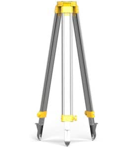
In the rapidly advancing field of drone technology, precision is key, particularly for applications that demand accuracy in navigation, mapping, and surveying. The DJI D-RTK 2 High Precision GNSS Mobile Station, paired with the DJI D-RTK 2 Tripod, is designed to meet these high standards, providing centimeter-level accuracy and robust performance even in challenging environments. This setup is essential for professionals who require reliable and precise positioning data for their drone operations.
Centimeter-Level Accuracy with GNSS Technology
At the core of the DJI D-RTK 2 High Precision GNSS Mobile Station is its ability to provide real-time kinematic (RTK) positioning, offering centimeter-level accuracy. Unlike traditional GPS, which can have an accuracy margin of several meters, RTK technology significantly reduces this margin, making it indispensable for applications such as aerial surveying, precision agriculture, and infrastructure inspections. The mobile station supports GPS, GLONASS, BeiDou, and Galileo satellite systems, ensuring that it can operate effectively anywhere in the world. By receiving signals from multiple satellite constellations, the DJI D-RTK 2 is able to maintain high precision even in areas where signal reception may be weak or obstructed.
Seamless Integration with DJI Drones
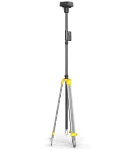
The DJI D-RTK 2 Mobile Station is designed to work seamlessly with a range of DJI drones, including the Matrice series. When paired with a compatible drone, the mobile station provides real-time differential corrections to the drone’s GNSS module, enhancing the accuracy of its positioning data. This integration is crucial for tasks that require precise georeferencing, such as creating high-resolution maps or conducting detailed inspections. Additionally, the mobile station is equipped with an OcuSync 2.0 data transmission system, which ensures stable and reliable communication between the station and the drone. This robust connection is vital for maintaining accuracy during complex operations, particularly in environments with potential signal interference.
Durability and Portability
Built with ruggedness in mind, the DJI D-RTK 2 is designed to withstand the demands of fieldwork. The mobile station is IP67-rated, meaning it is dustproof and waterproof, capable of operating in a wide range of weather conditions. This durability makes it suitable for use in diverse environments, from construction sites to remote agricultural fields. The accompanying DJI D-RTK 2 Tripod enhances the station’s stability, ensuring that it remains securely positioned during use. The tripod is easy to set up and transport, making it convenient for professionals who need to move between locations. Its sturdy design provides a reliable base for the mobile station, further contributing to the accuracy and consistency of the data collected.
User-Friendly Operation
One of the standout features of the DJI D-RTK 2 Mobile Station is its ease of use. The station is equipped with an intuitive interface and straightforward controls, allowing operators to quickly set up and begin their work. The mobile station can be configured and monitored through the DJI Pilot app, providing users with real-time status updates and ensuring that the station is operating optimally. The system’s portability, combined with its user-friendly design, makes it accessible to both seasoned professionals and those new to precision GNSS technology. The ability to deploy the station quickly and efficiently is especially valuable in time-sensitive operations where precision and speed are critical.
Versatility Across Applications
The DJI D-RTK 2 High Precision GNSS Mobile Station is versatile enough to be used in a variety of applications. In agriculture, it can be used to guide drones in precise crop spraying or field mapping, ensuring that every inch of land is covered accurately. In surveying and construction, the station enables the creation of detailed 3D models and maps, helping professionals make informed decisions based on accurate data. For infrastructure inspections, the mobile station provides the precise positioning needed to detect and document structural issues, allowing for proactive maintenance and repair. Its ability to maintain high accuracy in challenging environments makes it a valuable tool for any industry that relies on precision data.